Funzin Newsletter April 2026 |
|
|
Funzin, the AIoT specialist moving forward with joy, brings you our April updates! 😁
Hello, this is Funzin! We are excited to share another collection of Funzin’s latest achievements and news in this month’s newsletter.
[Highlights]
-
Funzin’s KWM-World: Unveiling the KWM-World Hierarchy
-
KWM-Ocelot Secures GS Certification Grade 1
-
The Era of Data Explosion, a New Battlefield Shaped by Satellite AI: An Interview on the Development of KWM-GIL
As a Vertical AI specialist, we will continue to lead the future of national security and defense. We ask for your continued interest and support in our journey. If you found this newsletter helpful, please subscribe and share it with your colleagues and friends! 😊 |
|
|
Unveiling the KWM-World Hierarchy
|
|
|
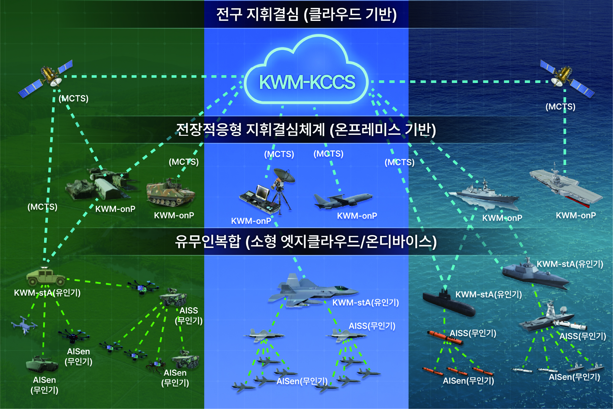
Funzin has unveiled the KWM-World Hierarchy, an innovative AI-powered command and decision support system applicable to all three military branches: the Army, Navy, and Air Force.
The core philosophy behind KWM-World is clear: "Instead of one giant AI controlling the entire battlefield, we provide the right-sized AI right where it's needed." Let's dive into the core of Funzin's customized AI lineup that will lead the future battlefield.
🔍 Core Components of KWM-World
☁️ KWM-KCCS (Theater-Level Decision Support / Cloud-Based) A high-performance, AI-based cloud command and decision system deployed for missions requiring massive and complex data processing, such as counter-fire operations and air defense.
💻 KWM-onP (Battlefield-Adaptive Decision Support / On-Premise) Optimized for field environments with frequent unit movements. Directly integrated into equipment (On-Premise), it supports immediate and flexible operational command tailored to dynamic on-site situations.
🚁 MUM-T (Manned-Unmanned Teaming) & On-Device AI Solutions
-
KWM-stA: Modular software integrated into manned aircraft to command and control the MUM-T system.
-
AISS & AIsen: Unmanned aerial vehicles (UAVs) and sensors equipped with self-aware, autonomous On-device AI to execute frontline missions.
📡 MCTS (The Battlefield Network Enabler) A core communication solution that ensures all these systems can exchange data seamlessly without interruption, even in the harsh and unstable communication environments typical of battlefields.
From the cloud to the edge, all the way to frontline on-device AI! Funzin's multi-layered AI solutions—optimized for the scale and conditions of any battlefield—are setting a new standard for future smart defense. |
|
|
KWM-Ocelot Achieves GS Certification Grade 1 |
|
|
KWM-Ocelot: Awarded the Highest Quality Certification (GS Grade 1) |
|
|
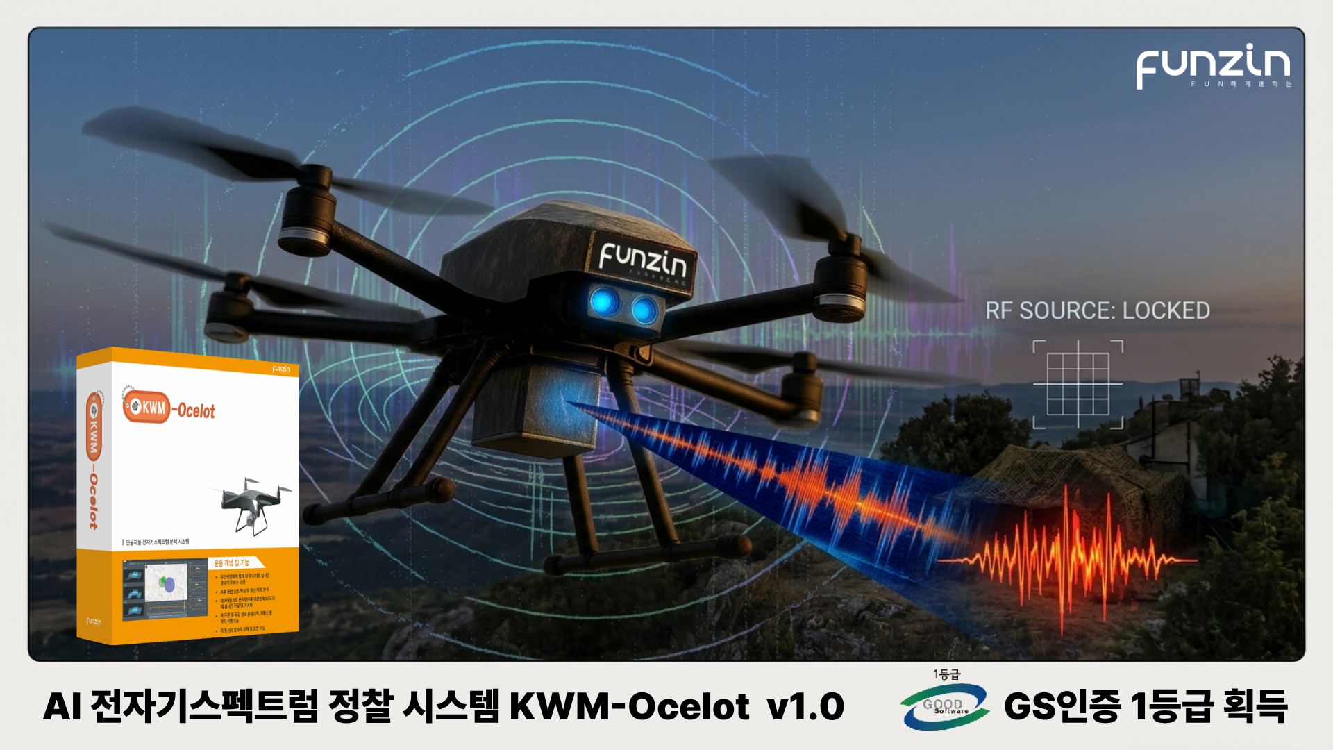
Funzin’s AI-powered electromagnetic spectrum reconnaissance system, 'KWM-Ocelot,' has officially received GS (Good Software) Certification Grade 1 after passing rigorous quality verification by the Telecommunications Technology Association (TTA). Here is a summary of Funzin's innovative technology that "sees through" invisible radio waves.
📡 What is KWM-Ocelot?
-
3D Radio Wave Visualization: It visualizes mobile communication and broadband signal data collected by reconnaissance devices, such as drones, by integrating it with 3D spatial information and time-series data.
-
Precision Location Tracking: Even in complex and noisy electromagnetic environments, it precisely detects specific signals and accurately identifies the exact source of the transmission.
|
|
|
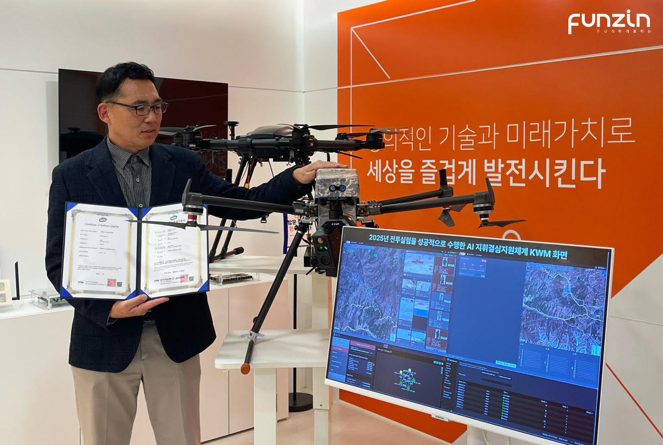
Vice President Ji-hoon Jeon explains a drone equipped with KWM-Ocelot technology
|
|
|
🎖️ Proven Performance in the Field
-
Award-Winning Technology: Following the 'Grand Prize at the Army AI Idea Contest' last May, the system received the 'Minister of National Defense Citation' in July for its contribution to the drone industry, gaining early recognition for its technical excellence.
-
Successful Combat Trials: Last October, it was deployed in combat experiments at the Korea Combat Training Center (KCTC) in Inje, Gangwon-do, proving its operational effectiveness on the battlefield. As a result, it is currently drawing significant interest from leading global defense companies.
🚀 The Next Step for KWM-Ocelot With this GS Grade 1 certification as a stepping stone, Funzin continues its R&D to maintain an overwhelming technological lead.
-
Applying Physics AI based on Physics-Informed Neural Networks (PINN).
-
Developing a 'World Foundation Model' specifically for the defense radio spectrum.
-
Ultimate Goal: To evolve the technology beyond simple location tracking, achieving a level where objects can be perfectly identified using only frequency detection data!
|
|
|
The Era of Data Explosion, a New Battlefield Shaped by Satellite AI: An Interview on the Development of KWM-GIL |
|
|
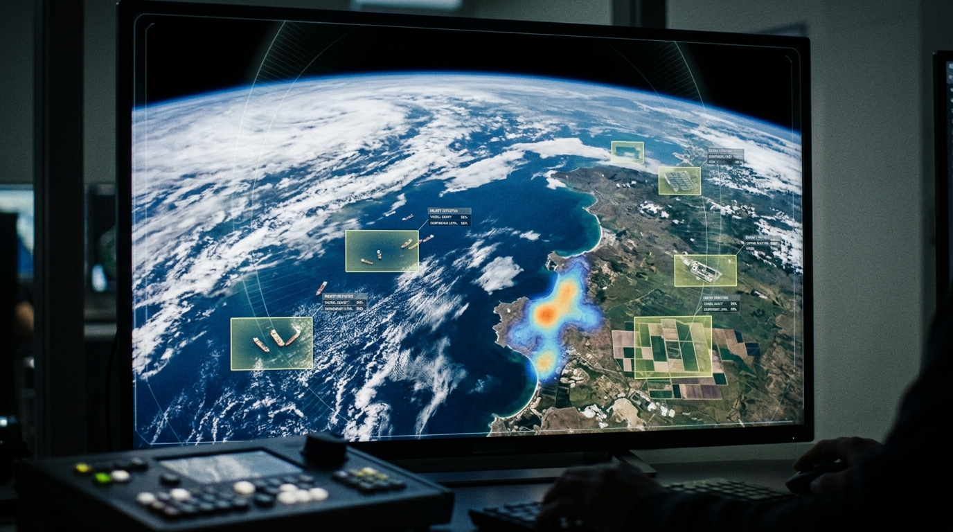
KWM-GIL Interface Example
|
|
|
The evolution of satellite AI stepping in for the human eye! What exactly is the newly launched 'KWM-GIL (GEOINT Layer)' solution being developed by Funzin? We sat down with Seung-hoon Shin, Head of the Research Center, to find out.
Q1. What is the primary driving force behind the development of the KWM-GIL solution?
A. While the volume of collected satellite data is increasing exponentially, the processing capacity of human analysts has its limits, leading to a growing "Intel Gap." KWM-GIL is a solution designed and developed to utilize AI as an assistive tool to reduce blind spots in intelligence analysis amidst this flood of data. While the value of individual data is crucial, we initiated this development because we determined that fusing multiple datasets generates new and even more valuable intelligence.
Q2. In which areas are you currently advancing information processing through the application of AI?
A. We are currently in the process of advancing three core areas that are fundamentally the most researched right now:
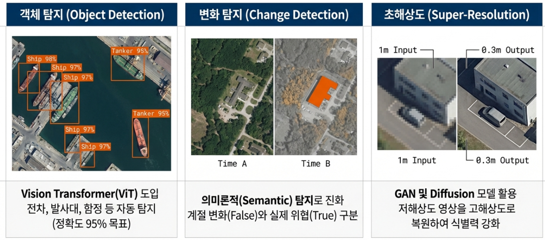
-
Object Detection: We are researching the automatic detection of tanks, missile launchers, and naval vessels by introducing the Vision Transformer (ViT) model, with an ultimate goal of achieving 95% accuracy.
-
Change Detection: We are testing technologies designed to identify meaningful differences from time-series imagery—specifically, comparing images taken at different timestamps.
-
Super-Resolution: We are conducting research to enhance the identifiability of low-resolution images using AI-based image quality enhancement technology.
We are currently focusing our advancements on these core areas. Moving forward, we plan to concentrate even more heavily on research that generates meaningful new intelligence through data fusion. |
|
|
Application and Advancement Areas of Satellite AI Technology
|
|
|
Q3. How do you plan to handle situations where the collected satellite imagery is of low resolution?
A. We are researching ways to overcome this limitation through 'Super-Resolution' technology. Currently, we are conducting tests using GAN (Generative Adversarial Networks) and Diffusion models to restore 1m-class low-resolution images to a 0.3m-class level. Our focus is on bringing out the clearest possible outlines of targets that are difficult to identify due to weather conditions or resolution issues.
Q4. In 'Change Detection,' how do you distinguish between simple seasonal changes and actual military threats?
A. That is one of the core challenges we are continuously refining our model training to address. We are advancing the system beyond simply comparing image pixel differences to enable 'Semantic Detection.' We are researching ways to minimize false positives by having the AI autonomously distinguish between natural changes—like falling snow or shedding leaves—and actual threats, such as troop movements or encampment construction.
To perform this semantic analysis flawlessly, it is necessary to fuse and interpret a variety of information. We must comprehensively evaluate factors such as the timeline of events, conflicts in specific regions, and rapid environmental changes. |
|
|
GEOINT Terrain Analysis and Mobility Assessment
|
|
|
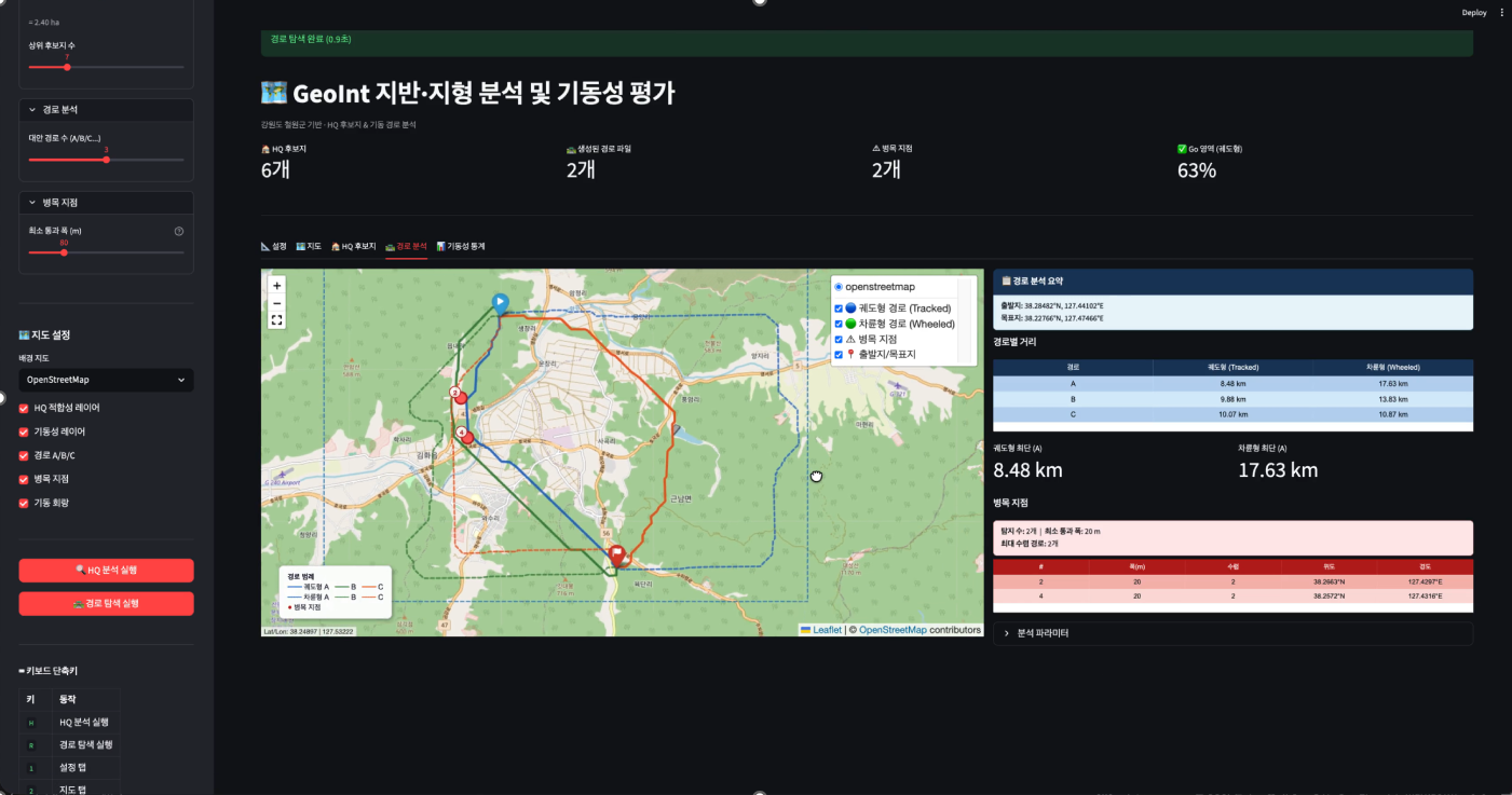
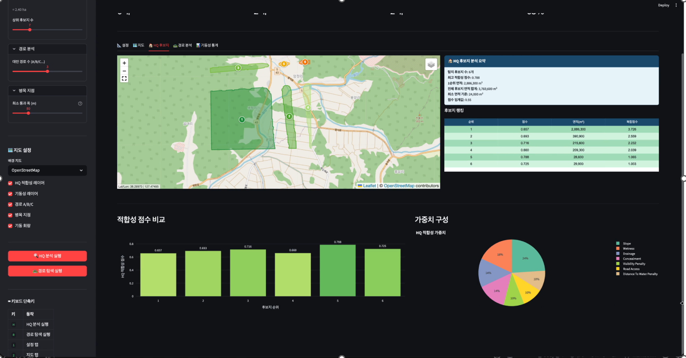
Q5. Once development is complete, how can this be utilized in the actual field?
A. By fusing diverse data such as optical and SAR (Synthetic Aperture Radar) satellite imagery, we are currently verifying the following application possibilities through our in-house development:
-
Military Operations: By fusing terrain and land data, we can analyze unit maneuver routes and select candidate sites for command headquarters. This can be utilized for maneuver route analysis when recommending attack strategies within our KWM system. Furthermore, it can be applied to predicting enemy behavior—if enemy activity is detected, it is used to estimate the locations of their command headquarters or main forces, and to analyze their expected maneuver routes.
-
Disaster Response and BDA: This involves time-series analysis of wildfires and damage scale assessment technology linked with fire point data. In a military context, this can be immediately applied to Battle Damage Assessment (BDA) for both friendly and enemy forces in the event of an engagement.
-
Maritime Border and Key Asset Surveillance: This technology automatically detects port entries and departures and tracks suspicious vessels by combining it with AIS (Automatic Identification System) data. These tracking capabilities will be instrumental in monitoring and identifying unusual activities at key enemy facilities (airfields, naval bases) and major assets (aircraft, warships, submarines, etc.).
To reduce the blind spots in vast amounts of satellite data that human eyes cannot reach, KWM-GIL is constantly learning and evolving even at this moment. Although it is still in development, the process of how this AI analysis solution—powered by diverse data fusion—will create synergy in the future of national defense and disaster surveillance is highly anticipated.
|
|
|
(`26.04.01.)
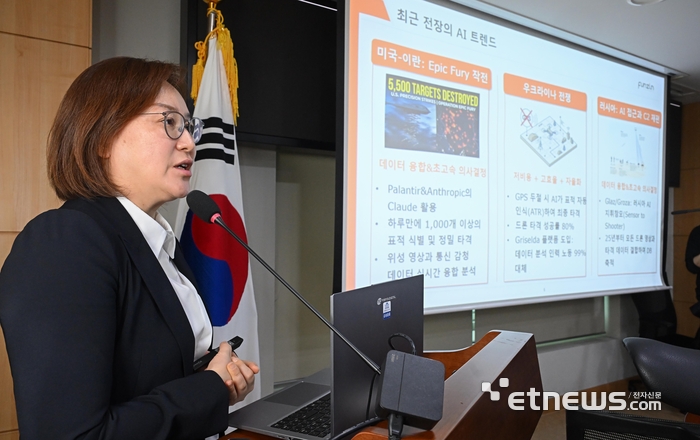
At an urgent panel discussion hosted by the Electronic Times on the 1st, titled 'AI Warfare through the Lens of the Iran War: Defense Innovation and Bioethics,' Funzin CEO Shirly shared his bold forecast for the future of defense.
"In future battlefields, alongside combat robots, an 'AI Advisor' capable of maximizing the potential of those robots must be deployed directly to the frontline—just like downloading an application from an App Store," he emphasized. CEO Kim further predicted, "The era of these Software-Defined Weapon (SDW) systems will arrive within the next three years."
|
|
|
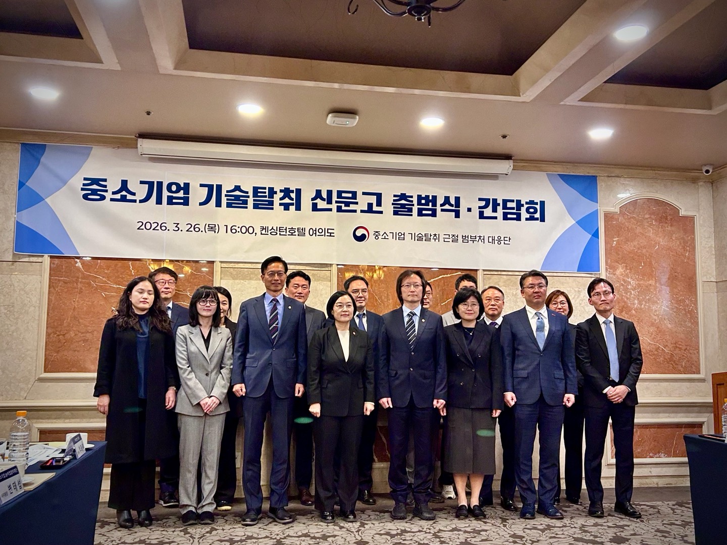
(`26.03.26.)
To mark the launch of the interagency 'SME Technology Theft Reporting Center,' government officials, industry experts, and small-to-medium enterprises (SMEs) gathered to review past achievements in technology protection and gather on-the-ground feedback for future improvements.
Recognized for its outstanding and robust internal technology protection system, Funzin was specially invited to attend the event and deliver valuable industry recommendations.
|
|
|
펀진
🏠 서울특별시 성동구 연무장5가길 7, 현대테라스타워 EAST동 13층
☎️ 02-929-9579~80
|
|
|
|
|